Biographies
Website
Help?
Bedfordshire
Berkshire
Buckinghamshire
Cambridgeshire
Cheshire
Cornwall
Cumberland
Derbyshire
Devonshire
Dorset
Durham
Essex
Gloucestershire
Hampshire
Herefordshire
Hertfordshire
Huntingdonshire
Kent
Lancashire
Leicestershire
Lincolnshire
London & Middlesex
Norfolk
Northamptonshire
Northumberland
Nottinghamshire
Oxfordshire
Rutland
Shropshire
Somersetshire
Staffordshire
Suffolk
Surrey
Sussex
Warwickshire
Westmorland
Wiltshire
Worcestershire
Yorkshire
British Isles
Channel Isles
Ireland
Scotland
Wales
World
Rest of Europe
Asia
Australia & New Zealand
Africa
Americas
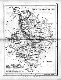
Huntingdonshire 1846
Drawn & Engraved by J. Archer especially for Thomas Dugdales; Curiosities of Great Britain England and Wales Delineated 1846.
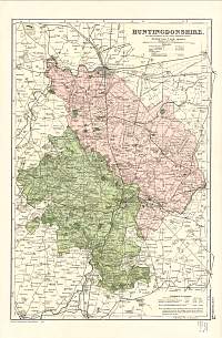
Huntingdonshire 1904 Bacon's Popular Atlas of the British Isles
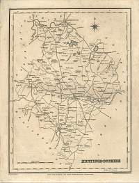
Huntingdonshire 1787 Cary
From John Cary's 1787 Atlas
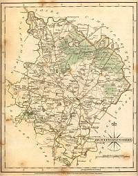
Huntingdonshire c.1835 R. Creighton map engraved for Lewis's Topographical Dictionary. Circa 1835
Parliamentary & County Atlas of Great Britain & Ireland. Maps by W. Hughes F.R.G.S. Published by J.S. Virtue 1886.
Copyright © 2003/2004/2005/2006 Your Old Books & Maps