Drawn & Engraved by J. Archer
especially for Thomas Dugdales; Curiosities of Great Britain
England and Wales Delineated 1846.
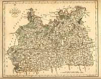
Surrey 1787 Cary
From John Cary's 1787 Atlas
Guildford and Horsham O/S Map
Sheet 124 Guildford and Horsham Popular Edition. One inch to the mile Ordnance
Survey map. This was surveyed 1866-75.
Published 1874-82, Revised 1887-1894, 3rd Revision 1912,
Minor corrections 1931.
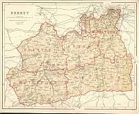
Surrey 1904
Bacon's Popular Atlas of the British Isles
Surrey
Parliamentary & County Atlas of Great Britain &
Ireland.
Maps by W. Hughes F.R.G.S.
Published by J.S. Virtue 1886.