 |
|
|
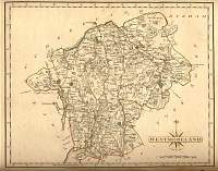
Westmorland 1787 Cary
From John Cary's 1787 Atlas
|
 |
|
|
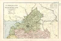
Cumberland & Westmorland
North 1904
Bacon's Popular Atlas of the
British Isles
|
 |
|
|
Cumberland & Westmorland
South 1904
Bacon's Popular Atlas of the
British Isles
|
 |
|
|
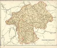
Westmorland c.1835
R. Creighton map engraved for Lewis's Topographical Dictionary. Circa 1835
|
 |
|
|
Westmorland 1808 Phillips |
 |
|
|
Westmorland
Parliamentary & County Atlas of Great Britain &
Ireland.
Maps by W. Hughes F.R.G.S.
Published by J.S. Virtue 1886. |
 |
|
