 |
|
|
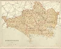
Dorsetshire 1846
Drawn & Engraved by J. Archer
especially for Thomas Dugdales; Curiosities of Great Britain
England and Wales Delineated 1846.
|
 |
|
|
Dorset 1886
Dorset map from Black's Guide to Dorset 1886 |
 |
|
|
Dorset 1898
Dorset map from Kelly's 1898 Directory. |
 |
|
|
Dorset 1904
Bacon's Popular Atlas of the British Isles
|
 |
|
|
Dorset 1787 John Cary
From John Cary's 1787 Atlas
|
 |
|
|
Dorset
Parliamentary & County Atlas of Great Britain &
Ireland.
Maps by W. Hughes F.R.G.S.
Published by J.S. Virtue 1886. |
 |
|
