Old Maps of Wiltshire |
|
|
Wiltshire 1846
Drawn & Engraved by J. Archer
especially for Thomas Dugdales; Curiosities of Great Britain
England and Wales Delineated 1846.
|
 |
|
|
Wiltshire 1898
Wiltshire map from Kelly's 1898 Directory. |
 |
|
|
Wiltshire 1787 Cary
From John Cary's 1787 Atlas
|
 |
|
|
Wiltshire 1890
|
 |
|
|
Wiltshire 1904
Bacon's Popular Atlas of the British Isles.
|
 |
|
|
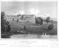
Bowood Park 1825
Wiltshire Country Houses. They all come from
J.P.Neale; Views of the Seats of Noblemen and Gentlemen in England, Wales,
Scotland and Ireland (1820s).
|
 |
|
|
Corsham House (North Front) 1825
Wiltshire Country Houses. They all come from
J.P.Neale; Views of the Seats of Noblemen and Gentlemen in England, Wales,
Scotland and Ireland (1820s).
|
 |
|
|
Corsham House (South Front) 1825
Wiltshire Country Houses. They all come from
J.P.Neale; Views of the Seats of Noblemen and Gentlemen in England, Wales,
Scotland and Ireland (1820s).
|
 |
|
|
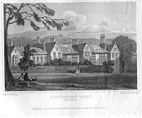
Littlecot Park 1821
Wiltshire Country Houses. They all come from
J.P.Neale; Views of the Seats of Noblemen and Gentlemen in England, Wales,
Scotland and Ireland (1820s).
|
 |
|
|
Lacock Abbey 1826
Wiltshire Country Houses. They all come from
J.P.Neale; Views of the Seats of Noblemen and Gentlemen in England, Wales,
Scotland and Ireland (1820s).
|
 |
|
|
Wiltshire
Parliamentary & County Atlas of Great Britain &
Ireland.
Maps by W. Hughes F.R.G.S.
Published by J.S. Virtue 1886. |
 |
|
