Old Maps of Wales |
|
Page
1 - Page 2 -
Page 3 -
Page 4
|
|
Monmouthshire 1846
Drawn & Engraved by J. Archer
especially for Thomas Dugdales; Curiosities of Great Britain
England and Wales Delineated 1846.
|
 |
|
|
Baron Hill, Anglesey.
Baron Hill, Anglesey. From Watts, Seats of the Nobility and Gentry, 1779
This house was designed by Samuel Wyatt, 1776 - 1779. It was gutted by fire in
1836. |
 |
|
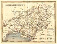
Carmarthenshire Mid 1800's.
Archer map of Carmarthenshire. Exact date not known. |
 |
|
Carnarvon Castle
1893 Gazetteer of England and Wales published by William Mackenzie. |
 |
|
Monmouth 1787 Cary
From John Cary's 1787 Atlas |
 |
|
|
Monmouth Railways 1905 |
 |
|
Monmouthshire c.1840
Monmouthshire published by Fullarton and Co. Glasgow and engraved by R. Scott.
Circa 1840 |
 |
|
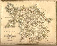
North Wales 1787 Cary
From John Cary's 1787 Atlas |
 |
|
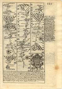
Strip map Carmarthenshire 1736.
Britannia Depicta
Route starting in Radnorshire travelling via Breconshire to Carmarthenshire. The
starting point 'Prestain' is I believe Presteigne (Powys) then via New Radnor
and 'Bealth' (Builth Wells) to Carmarthenshire |
 |
|
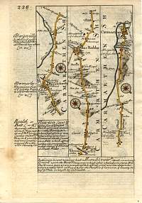
Strip map Carmarthenshire 1736.
This Strip Road Map comes from Emanuel Bowen and John Owen's Britannia Depicta
first published in 1720 and published up until 1760. This being from the 1736
edition. The road runs through the County of Carmarthenshire & the Towns of
Llanimdovery, Abermarles, Rue Raddor & Carmarthen. |
 |
|
|
Page
1 - Page 2 -
Page 3 -
Page 4
|
|
