 |
|
|
Warwickshire 1846
Drawn & Engraved by J. Archer
especially for Thomas Dugdales; Curiosities of Great Britain
England and Wales Delineated 1846.
|
 |
|
|
Warwickshire 1787 Cary
From John Cary's 1787 Atlas
|
 |
|
|
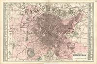
Bacon
Atlas 1883
Birmingham Town Plan
|
 |
|
|
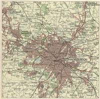
Birmingham 1904
Scanned from Bartholomew's Gazetteer of the British Isles 1904
|
 |
|
|
Warwickshire c. 1872
Showing the Parliamentary Divisions
J. Bartholomew
|
 |
|
|
Birmingham, Five Ways - Postcard
|
 |
|
|
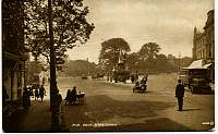
Birmingham, Hagley Road - Postcard
|
 |
|
|
Warwickshire 1904 Bacon
Bacon's Popular Atlas of the British Isles |
 |
|
|
Birmingham Times Atlas c.1920
Bartholomew
|
 |
|
|
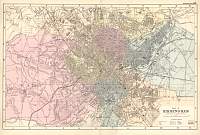
Birmingham c.1880’s Bacon
|
 |
|
|
Birmingham Dower/Orr & Smith |
 |
|
|
Warwickshire
Parliamentary & County Atlas of Great Britain &
Ireland.
Maps by W. Hughes F.R.G.S.
Published by J.S. Virtue 1886. |
 |
|
